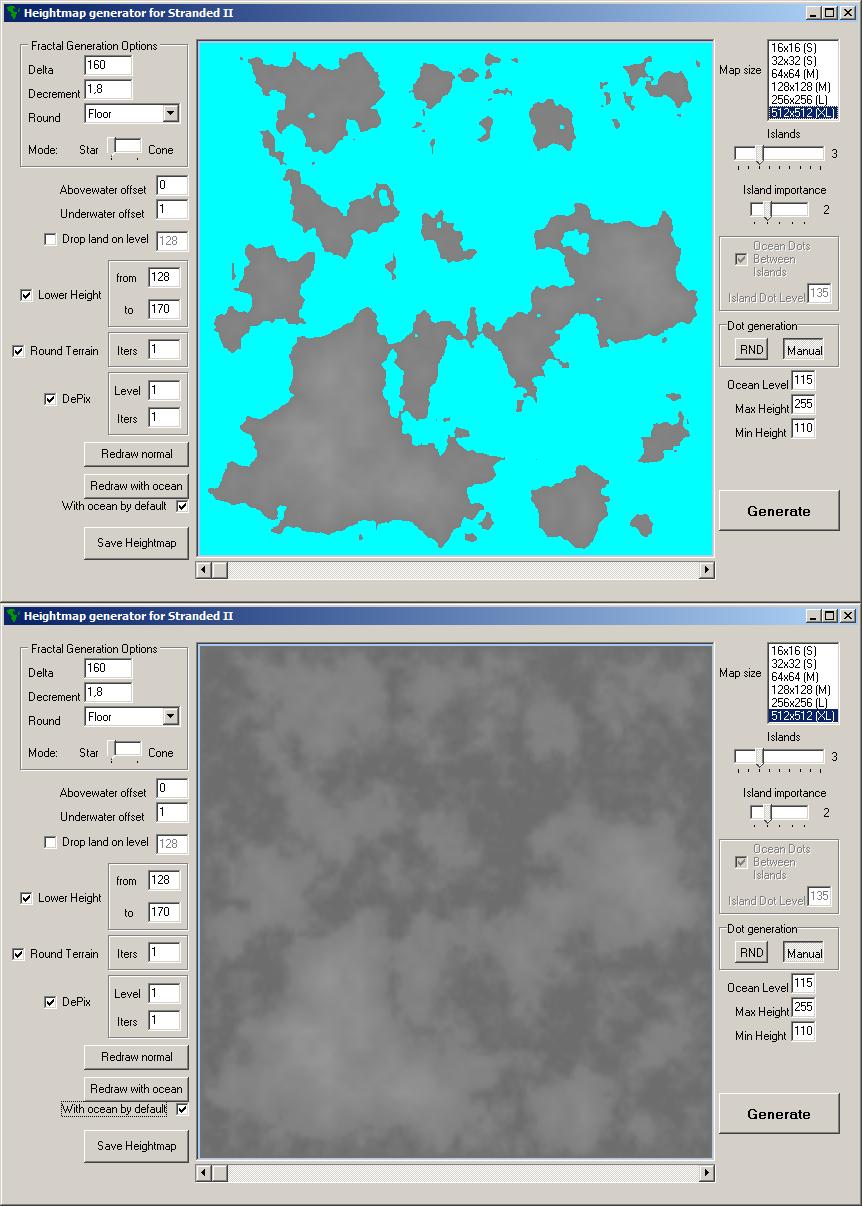
So, you run the program and see a lot of options. (see screenshot 1)
I'll try to explain each of them.
Fractal Generation Options:
The generation starts for big areas of the map, and ends with small ones. The
delta is the range for random value, which is added to the average of already generated pixels. For each iteration, the
delta is divided by
decrement. The less number
decrement is, the noisier terrain would be. Delta also can be rounded after every time it gets divided. That's the third fractal generation option.
Abovewater/Underwater offsets: The line between land and water can be too smooth, that results in shallow water and ugly one-pixel islands.
Abovewater offset value is added to each pixel above the sea level, and the pixels below the sea level are lowered by
underwater offset value.
The "Drop land" option makes every pixel between water level and the given level exactly water level. The water level is 127, by the way

Islands and their "importance":
1 is the most important, 5 is the less important. The island with first importance is always in the center, and it affects generation on first iterations, while the island with fifth importance can remain being just one pixel. The important islands have the better chance to become something big, but they still keep a chance to be very small.
Ocean dots are generated in the middle of each pair of islands. You can pick maximum of 25 islands, but keep in mind that too many would make the map "crowded" with islands and water spots, and that would look pretty ugly. The generated island dots have the
Island dot level and ocean dots have the
Ocean level. The map borders also have
Ocean level.
Also you can place these dots manually in the
manual mode.
Redraw with ocean draws the heightmap with "Aqua" color instead of pixels below the water level, and
Redraw normal returns grayscale back. Don't worry, the
Save Heightmap button redraws the map normal before saving the heightmap.
The scrollbar under the map is a zoom bar.
The
Lower Height option allows you to scale down any height that is higher than "from" value to "fit" the gap between "from" and "to" heights.
The
Round option allows you to round the map right after it is generated. You can set iterations (how many times the map gets rounded).
The
DePix option removes these ugly one-pixel islands.
Its level means how many pixels above ocean level must be near a pixel for it to remain above the water. (Corner pixels don't count, so level 4 and higher just makes the map empty).

 Heightmap Generator |upd.2|
  7 mögen es!
 Offline


 Download
 1
1 
 Marcines24: You saved the heightmap, right? Now you need to:
 open S2 editor;
 At first I made this program for myself, because I wanted to see more than 1 island at "Big" map size, so I could actually use a raft to travel.